Nolli’s plan is valuable not only because it presents a cartographic record of Rome that was unprecedented in its detail and accuracy, but also because it does so at a very fortuitous moment, perched as it is between the early modern and modern changes that so drastically altered the city.
On the one hand, the map is a summation of three centuries of dramatic
urban changes to Rome’s fabric that began when the papacy returned in
the early 1400s.
Infrastructural interventions are meticulously
documented, including the laying out of new streets such as the
tridents originating at
Piazza del Popolo and
Ponte Sant’Angelo; water supplies,
such as the aqua Virgo and
Trevi Fountain; public spaces such
as the Campidoglio, and bridges, as
the Ponte Sisto (n. 732).
On the other hand, Nolli’s map preserves a crystalline vision of a
city that began to change again, just as radically, after Rome became
capital in 1871. This essay will explore a few of the many important
urban features recorded by Nolli that were later demolished and/or
refashioned in the interests of modernization and, often, ideology.
The most famous—or infamous—of these sites stretches from Piazza Venezia (n. 906), at the beating heart of Rome’s historical core, south to the Colosseum, just a half mile away. But what a half mile it is, redolent of illustrious history as it traces a path between the Roman and imperial fora, littered with some of Rome’s most important ruins.
Marking the southern terminus of
Via del Corso and just steps from the
base of the Capitoline Hill, Piazza Venezia was the setting for the
eponymous palace, built in the
mid-fifteenth century for Cardinal Pietro Barbo, who became Pope Paul
II in 1464.
 Palazzo Venezia (source
wikimedia commons)
Palazzo Venezia (source
wikimedia commons)
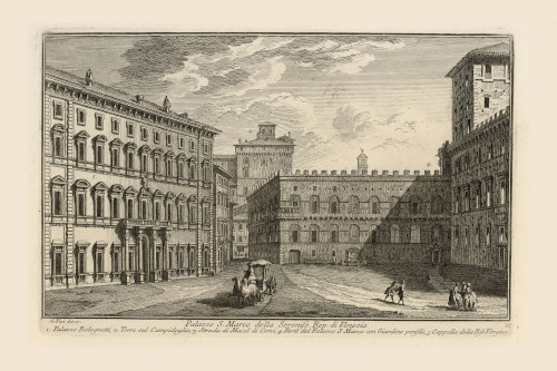
Nolli shows the piazza as a narrow
rectangular space adjoining the palace, which enfolded the medieval
church of San Marco (n. 907) as
well as an unfinished early Renaissance classicizing
courtyard (n. 903).
Similarly Vasi (image below) illustrates how
Via del Corso enters the piazza at its
northeast corner, but its straight, wide path dissolves into a
curving, narrower alley as it exits the other side of the piazza, at
the southeast corner. Otherwise, the southern end of the piazza is
closed off by the so-called
Palazzetto (n. 905): an enclosed,
arcaded garden annexed to Palazzo Venezia via the tower at its
southeast corner.
 Piazza Venezia, looking south (source
Vasi Website)
Piazza Venezia, looking south (source
Vasi Website)
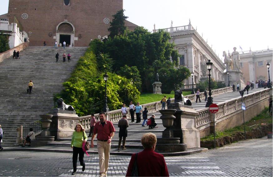
Moving further south from Piazza Venezia, irregularly defined city blocks and densely packed buildings separate that space from the Capitoline Hill. There, Santa Maria in Aracoeli (n. 917) is shown fronted by its steep, ample staircase, adjoining Michelangelo’s Campidoglio with its trapezoidal piazza flanked by mirrored palace fronts and approached by its own theatrical staircase, known as the cordonata.
South of the Capitoline, the Campo Vaccino—or “cow field”—as the site of the Roman Forum was known, appears as a large, barren space containing surprisingly few identified ruins. A tree-lined axis leads diagonally down its center from the Arch of Septimius Severus (n. 96) to the Arch of Titus (n. 73). To the east (right), the path is flanked by prominent ruins, medieval and later churches, and dense construction, while the Palatine—site of the Renaissance garden known as the Villa Farnesiana as well as the ruins of ancient imperial residences—rises to the west.
South of the Arch of Titus, the path continues past the ancient fountain known as the Meta Sudans (n. 934; destroyed in the 1930s), the Arch of Constantine (n. 935), and on to the Colosseum.

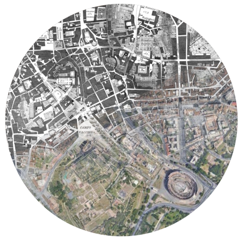
The extent of the post-Nolli changes to this zone becomes evident by means of the Interactive Nolli Map Website. The Layers tab at left allows users to switch on Modern Buildings, as depicted at left, and thereby to witness a drastic transformation to this part of Rome. This transformation requires a bit of unpacking, however, for there is as much lost as there is gained in Rome from 1748 to the present. Keep in mind that in this central section of the city, the orange built fabric superimposed in three dimensions upon Nolli’s orthogonal plan does not necessarily signal modern buildings in the sense of post-Nolli construction. Rather, in the majority of cases, it signals construction that existed in Nolli’s time and remains standing today.
Conversely, any built fabric that appears in Nolli but is left gray and two-dimensional (as opposed to projecting in orange) no longer exists—and a great deal of the area in and south of Piazza Venezia fits this description. With the exception of one highly conspicuous later building—the hulking monument to Victor Emmanuel II (commonly called the Vittoriano), which landed like an alien spaceship built from gleaming Brescian marble on the northern side of the Capitoline at the beginning of the twentieth century—a great swath of space has been cleared from Piazza Venezia to the Colosseum.
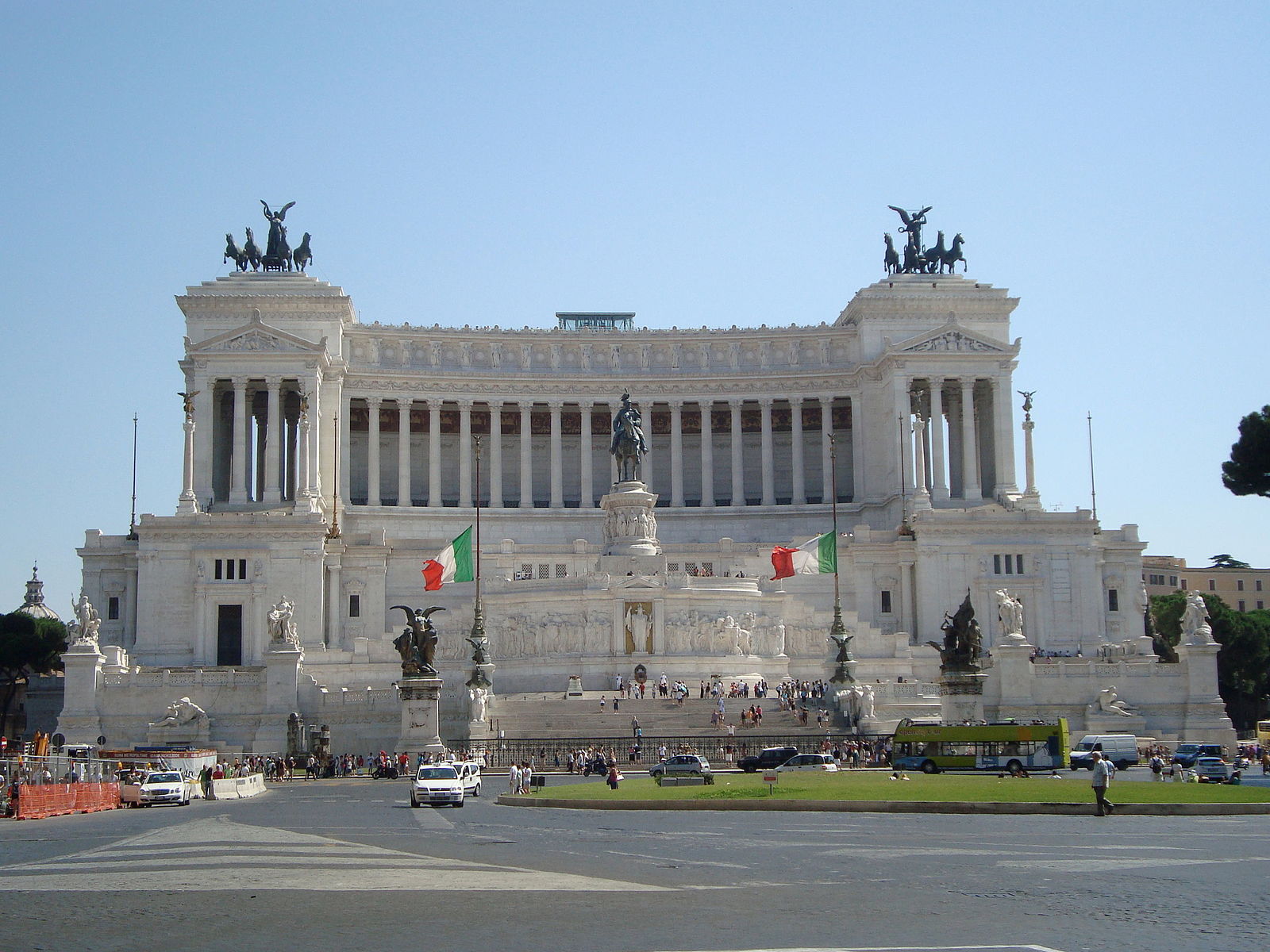 Monument to Victor Emmanuel II (source
wikimedia commons)
Monument to Victor Emmanuel II (source
wikimedia commons)
In other words, what has transpired here since Nolli is not an accumulation of built layers such as one might expect over almost three centuries, but rather a drastic erasure of them.
The demolition in this zone began to pick up steam in the early 1800s with papally sponsored excavations in the imperial fora. The Map Index in the Interactive Nolli Map Website permits users to click on identified sites and see metadata regarding their history, what became of them and when. The 1812 excavation of the Basilica Ulpia in the Forum of Trajan, for example, prompted the destruction of buildings that appear on Nolli such as Santo Spirito ai Monti (n. 114) with the adjacent Sant’Eufemia and allied convent (n. 115).
Transformations to the area around Piazza Venezia accelerated dramatically after 1871, however, with the project to construct the Vittoriano. To make way for that monument, a number of residential buildings and noteworthy structures were sacrificed, including the oratory and confraternity of San Gregorio Taumaturgo (n. 908) and Palazzo Circi (n. 909).
Piazza Venezia itself was expanded in the first decades of the 1900s to provide a grander setting for the monument, leading to the destruction of Palazzo Bolognetti-Torlonia (n. 277)and Palazzo Parracciani (n. 276).
The Palazzetto Venezia, meanwhile, was painstakingly moved a few dozen meters to the west to enlarge the piazza and to open the view from Via del Corso. Also destroyed nearby was the home where Michelangelo had resided for nearly thirty years, on Via Macel de’ Corvi near the eponymous piazza (n. 112).
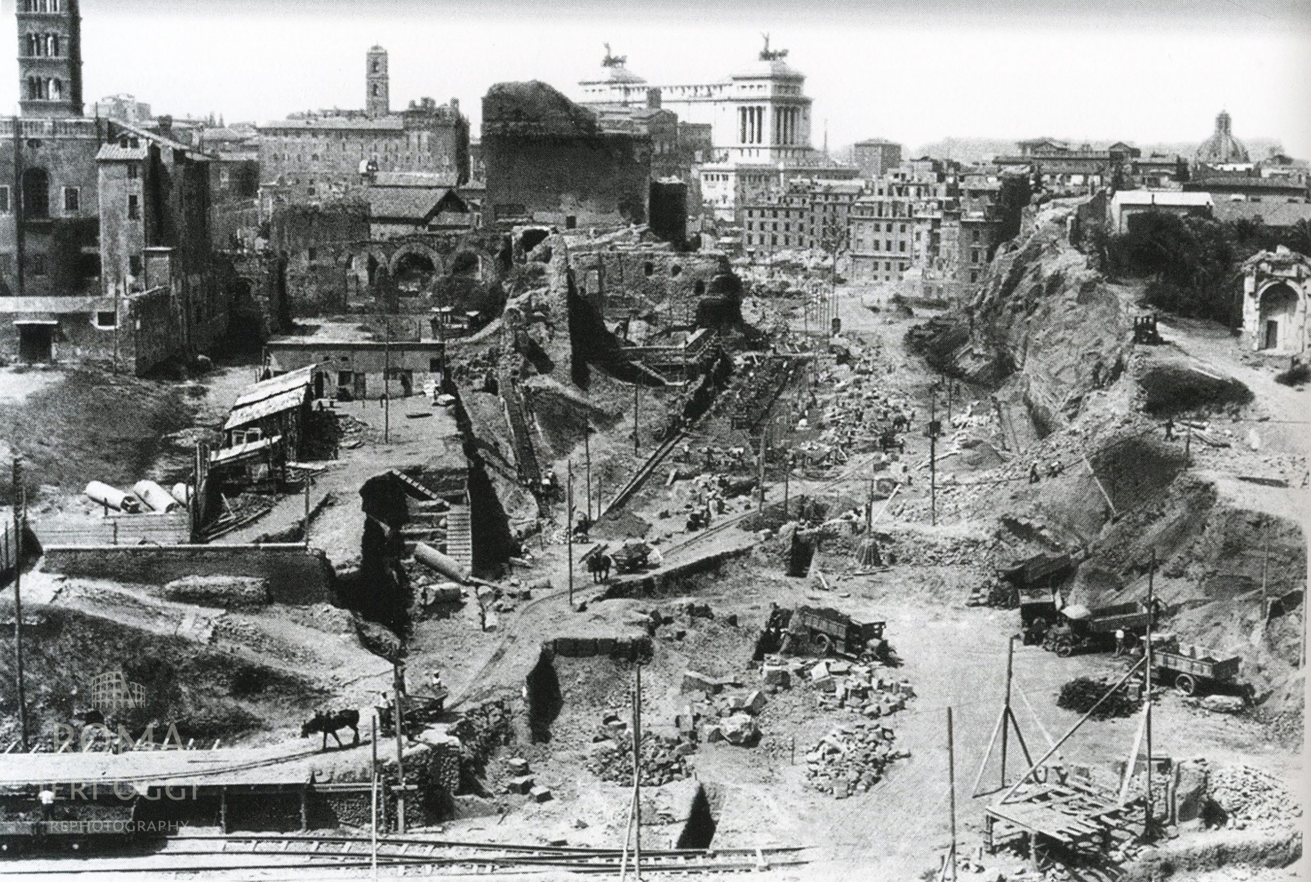
The most extreme demolition came under Mussolini, who made Palazzo Venezia his headquarters, further expanding the piazza around it in the 1930s to better accommodate the huge crowds of admirers he wished to attract… and harangue. Similarly, for the sake of staging military parades, Mussolini’s planners were responsible for slashing the 30-meter-wide Via dell’Impero (later Via dei Fori Imperiali) between Piazza Venezia and the Colosseum.
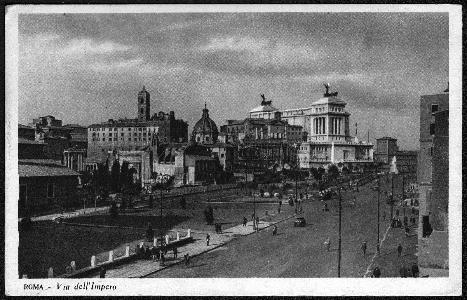 Via dell'Impero (source
wikimedia commons)
Via dell'Impero (source
wikimedia commons)
A whole vibrant working-class neighborhood was flattened to make way for this pompous thoroughfare, causing thousands of Romans to be relocated to new, subpar housing on the city’s periphery.
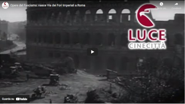 Click on the image to view video (source:
Istituto Luce)
Click on the image to view video (source:
Istituto Luce)
In addition to the human toll, interspersed in that neighborhood’s medieval and Renaissance fabric were religious buildings dating from the Middle Ages through Baroque period such as San Lorenzo ai Monti (n. 106) ; Sant’Agata dei Tessitori (n. 92) , later renamed Santa Maria in Macello Martyrum; and Sant’Urbano ai Pantani with its Capuchin (or Poor Clare) nunnery (n. 103).
 Santa Maria in Macello Martyrum (source
wikimedia commons)
Santa Maria in Macello Martyrum (source
wikimedia commons)
Here and there amid this urban wasteland, small twig-like bits of orange construction appear, particularly in the areas of the Roman and Imperial Fora that flanked the new avenue. These are in fact ruins whose appearance—or rather reappearance—reflects extensive excavations that began after 1871, spurred in part by a nationalistic desire to connect modern Roma Capitale symbolically with the ancient Caput mundi. These campaigns accelerated under Mussolini, whose propaganda machine was geared toward linking his persona with the great Roman emperors, deploying archaeology as well as urbanism to do so.
Fascist-sponsored archaeology was selective, however. It distinctly favored Rome’s ancient and Renaissance classical heritage, with little appreciation for anything medieval. Even within the classical category, Mussolini only deemed certain ruins worthy of unearthing and, often, reconstructing from fragmentary remains — while others were deemed less important, their relics neglected and damaged in the course of hasty, overblown modern construction projects. In the rush to lay out the Via dell’Impero archaeologists had to pile countless findings from the fora into crates and then storage without properly documenting them. Quickly unearthed, essentially pillaged, then just as quickly paved over — this incredibly rich archaeological zone suffered inestimable and irreparable damage in the 1930s, as did the living neighborhood that had peacefully coexisted with the ruins on a higher stratum of their shared site.
Many additional examples of urban sventramenti — literally, disembowelments — can be identified in the Nolli - and - after contrasts permitted by the layers feature of the Map Engine. In the area around the Vatican, for example, the absence of orange on the axis leading to St. Peter’s signals another Fascist avenue, Via della Conciliazione , the path of which condemned dozens of Renaissance and Baroque palaces to the wrecking ball. Northeast of the Vatican, however, the profusion of rectilinear orange apartment blocks laid out on a rational grid plan reveals a coordinated campaign of construction, not demolition: namely, the introduction of Rome’s first extramural neighborhood, Prati di Castello, planned from the 1870s but only brought to fruition in the first decades of the twentieth century.
Another feature of the Interactive Nolli Map Website is that it permits you to toggle between layers — selecting not only modern buildings or Nolli but also satellite imagery in order to truly grasp how much a given site has changed (or not). Via della Conciliazione is revealed clearly as an erasure of existing fabric, almost a gash, while Prati is a manmade environment superimposed upon what had been pastureland in Nolli’s time.
Across the city, another crop of new, rationally planned neighborhoods is evident on the Esquiline Hill around Termini train station. This area, also largely bucolic in Nolli’s time, encapsulates Rome’s radical growth after 1871, as it hurtled, sometimes painfully, into modernity (as does the arrival of the railway itself: a hugely important addition to Rome’s post - industrial cityscape).
Ultimately, Rome would also hurtle well past the confines of the Aurelian Wall and, for that matter, of Nolli’s margins.