Nolli's Tiber River
Katherine Rinne
Visiting Scholar
The Center for Cultural Landscapes
School of Architecture, UVA

Cleaving unequal halves of its right and left banks, the Tiber River is instantly identifiable as it meanders through Rome in Giambattista Nolli’s Pianta Grande of 1748. Filled with fascinating and useful information, Nolli’s map is an invitation to join him and his contemporaries Giuseppe Vasi, Andrea Chiesa, and Bernardo Gambarini as they float downriver in a small flat-bottomed skiff. Let us journey back to the eighteenth century and drift down the Tiber as Rome unfolds along its banks.
At first it seems there isn’t much to see on the bluff running along the right bank. As far as Castel Sant’Angelo there are vineyards and occasional trees popping up within them. While the right bank offers a tidy summation of agriculture in Rome, the left bank provides a glimpse of the city’s commercial life. Immediately after the outfalls—where sewers empty into the river—there is the Porto della Legna di Lavoro (the port for lumber intended for wood-working) outside the Aurelian Walls. Soon there are steps between the Porto della Legna (wood for burning) and the shore. Since timber came primarily from the north, the Tiber was the most economical and direct way to get it to market. Vasi has clearly turned up his nose and did not see fit to illustrate any of this in his Ponti di Roma e Vedute sul Tevere of 1743. Fortunately he did include other ports that we’ll encounter along the way.
Returning to the right bank we see that among the carefully laid out vineyards there is a small stream flowing toward the Tiber. It was called the Acqua della Valle dell’Inferno (Hell Valley Stream), named for the brick kilns farther upstream that existed from antiquity into the 1960s. Among the neat rows of vines (identified with their owner’s names) is the Vigna Altoviti. We’ll be there in a few minutes, but first we must arrange our passage under the ferry owner’s towline up ahead.
The San Martino ferry crossing was originally located at a posterula, a postern gate, in the ancient Aurelian Walls along the river. There were several posterule, often with a small port and, occasionally, a ferry crossing. By 1748 the Walls and postern gates were gone but the ports and ferries remained. Like the trees in the vineyards, Nolli has drawn the towline, ferryboat, and ships from an oblique angle making them easy to spot. Nolli illustrates the fluid form of the Porto di Ripetta designed in 1702 by Alessandro Specchi—the period’s most famous architect. The map hints at how busy it became during the mid-eighteenth century.
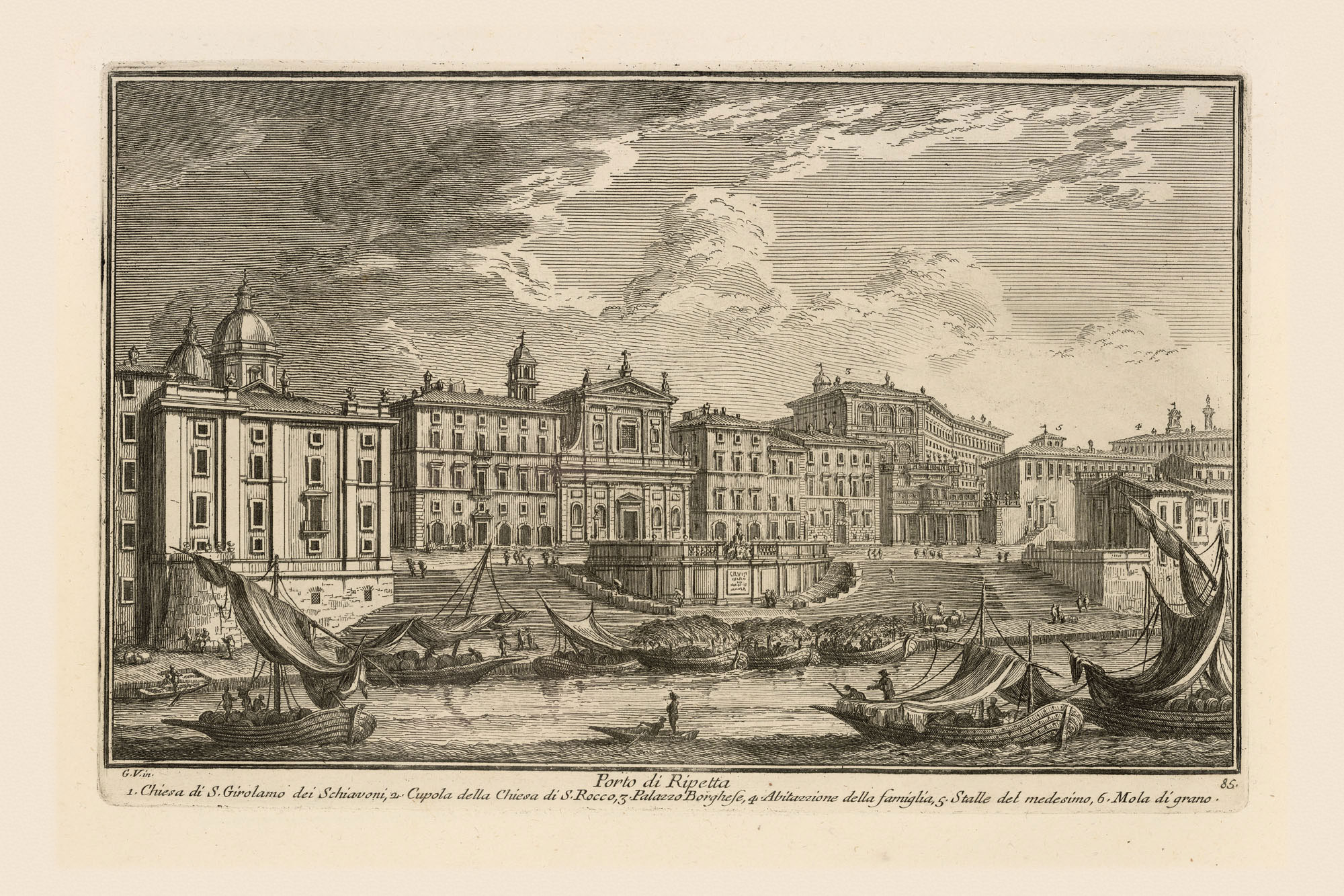
But it is Vasi (above) who brings the plan to life. We see cityscape façades including the church of S. Girolamo degli Schiavoni (n. 459) near the center, the laden boats with their sails, and the sweep and flow of the stairs down to the river.
Vasi’s viewpoint is from the Vigna Altoviti across the river. Like the Ripetta, the villa unfortunately no longer exists. But in Nolli’s plan we see a long river landing opposite the Ripetta, sweeping rows of trees (perhaps Plane trees noted for providing the deepest and coolest shade), a villa building, and formal gardens on the bluff above the shoreline. One hundred years later Pope Pius IX (r. 1846-1878) used that landing as his “marina,” as illustrated in a photograph from Rodolfo Lanciani’s archive.

Floating past the Ripetta, we’re left wondering about that ferry line positioned above the ship-filled port. It must have been a nuisance for ferrymen and sailors to keep out of each other’s way. How did they negotiate passage? What is not made clear by Nolli is how high the towline must have been placed to ensure that boats could pass beneath it. Vasi does not help in this matter either.
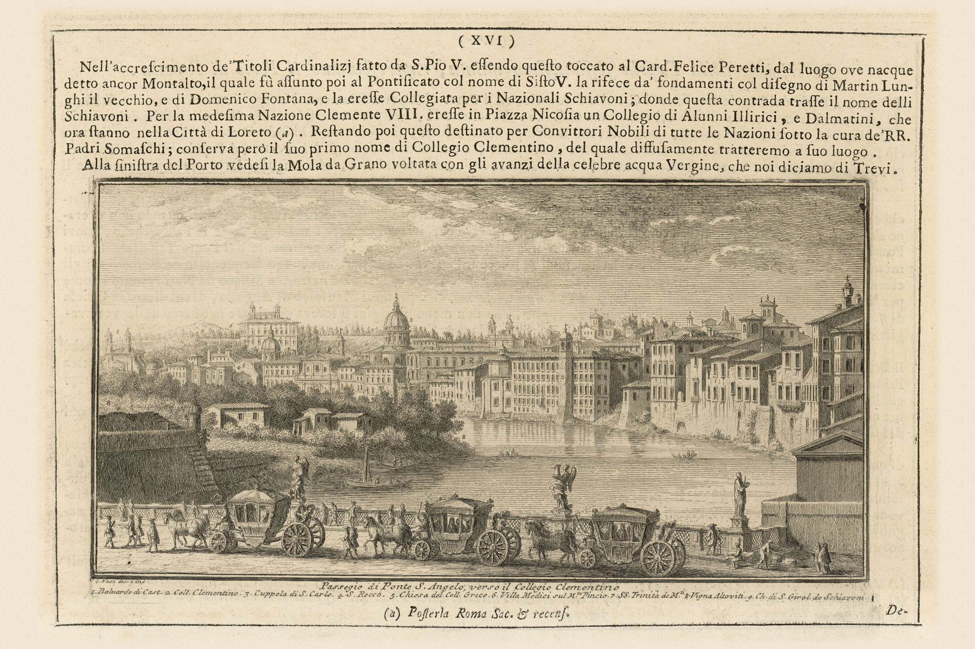
Let’s hasten downstream toward Castel Sant’Angelo (n. 1319) and Ponte Sant’Angelo (n. 1318); these were the ancient Mausoleum of Hadrian and the Pons Aelius, respectively. Filarete praised the ancient pons (bridge) for its proportions, composition, and beauty in his Trattato di Architettura of 1464. To embellish it further, Clement VII (r. 1523-1534) had statues of Saints Peter and Paul mounted on the left bank entry, and Clement IX (r. 1667-1669) commissioned Bernini’s ten angels that flutter above the balustrades. Vasi's view, below, turns our gaze upstream, from where we came. He included a defilade of carriages along the length of the bridge. Visible, too, are Bernini's angels.
Water flows fastest in the center of a river. Knowing this we immediately understand the design strategy in the Pons Aelius as drawn by Nolli who shows four piers, which means there are five arches. A central pier would have blocked the river’s flow—something to be avoided, especially during floods. This design explains, in part, why the bridge (damaged and restored many times) is still standing. It’s along the banks where most of the trouble lies. Nolli shows irregular riverbanks but Vasi, below, convincingly illustrates the river’s dynamics.
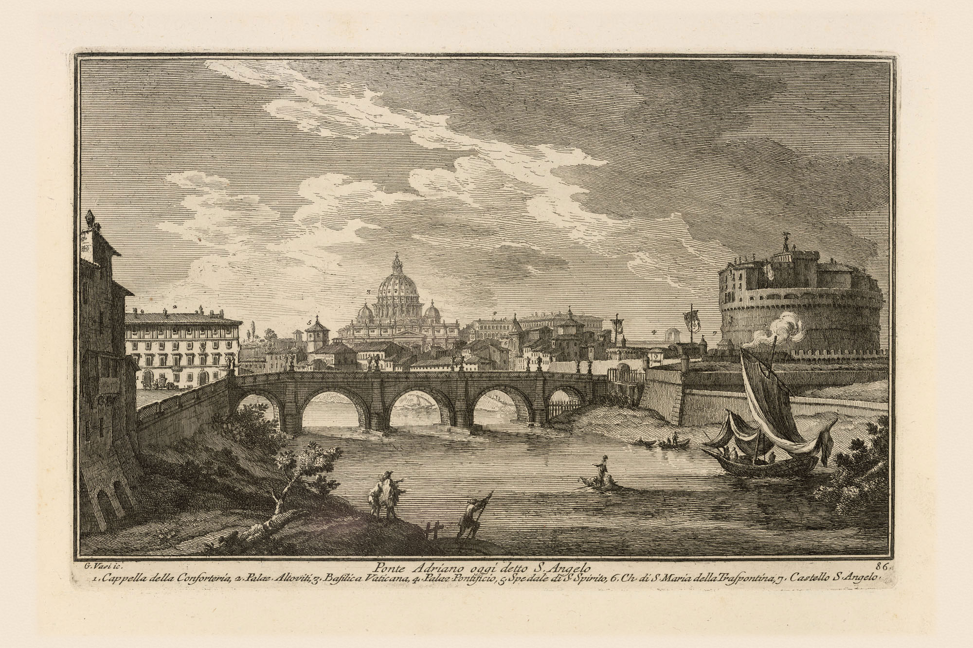
On the right bank we see a beach beneath the foundation wall of Castel Sant’Angelo. On the left bank there is an even larger beach. Both were formed from alluvial soil deposited by Tiber floods.
Andrea Chiesa and Bernardo Gambarini, who surveyed and mapped the river for Pope Benedict XIV (r.1740-1758), include a section elevation of Ponte Sant’Angelo in their map of the Tiber created between 1744 and 1746. With exquisite detail they reveal the angel’s wings and the lattice of the balustrade. They show the extent of the Castel Sant’Angelo beach and an extra, much smaller, arch that has been blocked behind it. Their section cuts through the uneven riverbed and, most interestingly, includes the spring and summer river levels in 1744 and the level of the 1742 flood near the tops of the arches. So much information in a single drawing! Brought together, Vasi’s 1742 view, Chiesa and Gambarini’s 1746 map and section, and Nolli’s 1748 plan provide an exceptional picture of the bridge and its relationship to the river.

Rounding the bend past Ponte Sant’Angelo, Nolli indicates that we’re about to hit what passes for white water in the Tiber. At this point, the Ospedale di Santo Spirito (nos. 1242 and 1243) complex (a Renaissance hospital) becomes visible along the right bank. The spacing of his fluttery river lines indicates that we need to stay toward the center of the river and pass safely between the second and third piers of the ruined ancient Pons Neronianus (which Nolli calls Ponte Trionfale, n. 541), and avoid the floating mills moored along the shore. These are the first mills we’ve encountered but we’ll see more downriver.
In the meantime, look at Vasi’s animated and informative view:
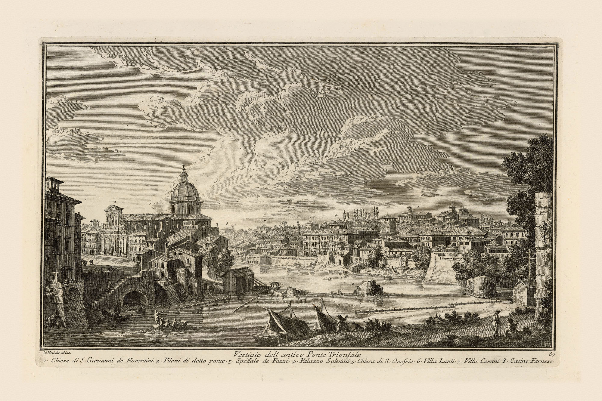
with buildings and garden walls standing in the water on both banks; a mill with its palisades (underwater walls meant to direct more and faster water to the mill); ruins of Ponte Trionfale looming ahead; steps to the top of the banks at Porto della Barchetta leading to Strada della Lungara; and in the distance there is the tree line of the Janiculum Hill. Adding Chiesa and Gambarini’s underwater section at Ponte Trionfale, the treachery of the ruins is revealed. Today, most of the ruins have been removed but you can still see some toward the left bank, especially when the river is low.

Once clear of the ruins there is another ferry towline to negotiate.
Looking further downriver there are more of these pesky lines crossing
the river. So we don’t interfere with traffic, we can pull up at the
small beach just beyond Porto della Barchetta, between the “F” and “I”
in FIUME.
From here we can see something astounding. Across the river is the
church of
S. Giovanni dei Fiorentini (n. 549), the
national church of the Florentines in Rome. Looking at the building’s
foundations we see that the apse is actually built over the water!
Nolli hints at this but from the little port we can see it clearly.
This is somewhat disturbing.
The story of the church’s construction is one of daring-do; its location, at an ancient oxbow where the Tiber liked to chew up the bank, is absolutely wrong. Here, the river gouged out the right bank, dumping its alluvium farther downstream, then it flew around the curve to do the same thing to the left bank. See how Nolli has indicated the river’s action on the right bank where the Pons Neronianus once met the shore. The bridge, too, is in the wrong place and its presence further eroded the vulnerable riverbank. Successive architects at S. Giovanni despaired for 150 years, but finally completed the church in 1743! Everything that made this bend the wrong place for the church and the bridge made it a perfect spot for floating mills as at the Ponte Trionfale ruins.
From here we can drift a bit until we reach the Barchetta all’Armata, another ferry crossing.
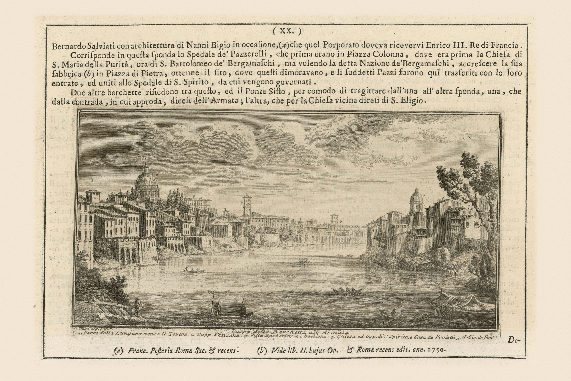
Vasi has us turn back to survey the area we just left. On the far left he shows stairs down to the ferry landing. In the middle distance are several private boats crossing the river. Now we realize how uncommon it was for a private pleasure boat such as ours to sail down the river past the Ripetta. One hired someone to row across the Tiber, or lacking a private ferry, one paid the ferryman.
Between Nolli and Vasi we’ve learned a lot. We have a clear image of how buildings and garden foundation walls came down to the river. We learned of some “beaches.” And we know that buildings and streets had sewers and drains flowing to the river—Nolli shows us six between S. Giovanni dei Fiorentini and the left bank Barchetta all’Armata landing (you can count them by “traveling back” upstream on the map at left). And now that you know what the outfalls look like, see if you can spot others along the way. Any time the Tiber flooded, water pushed through the drains into the basements (and sometimes the ground floors) and onto streets placed at lower elevations.
Pulling over to the left bank at the landing of the Barchetta all’Armata, and turning our view downstream, Vasi provides a view of Ponte Sisto (n. 732) and the Casino Farnese, now called Villa Farnesina (n. 1211).
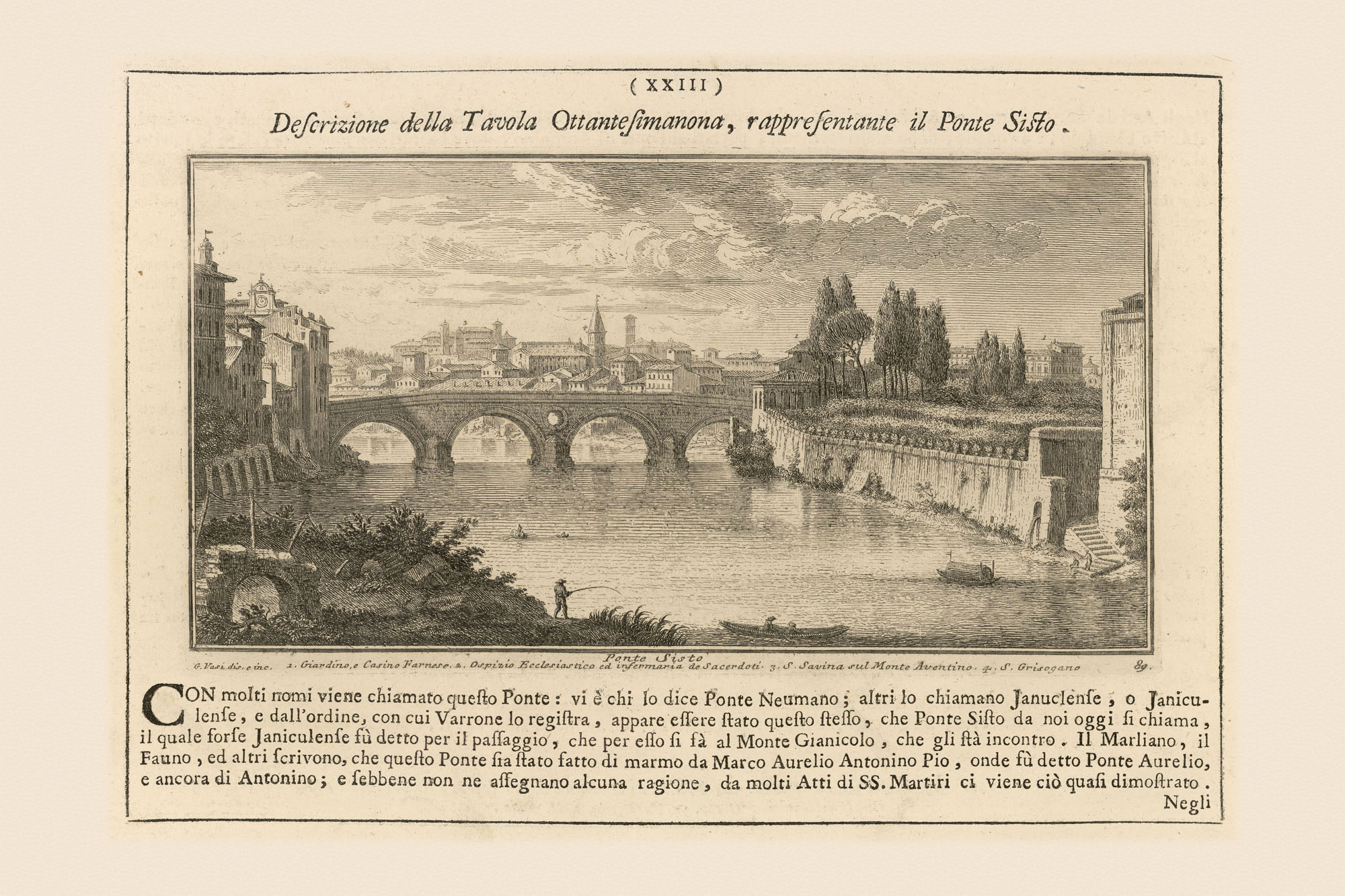
Looking at Nolli’s plan we see that Vasi has us standing at a sewer outfall. How thoughtful. To push home this truth he has depicted a fisherman. Eighteenth-century fisher folk could tell you that sewer outfalls were the best fishing spots—lots of tasty morsels washing down to the river! Our view is of Ponte Sisto and the Farnese garden wall. Down at the river level that would have been all we could see. Nolli makes clear how far the Farnesina gardens and the adjoining S. Giacomo jutted into the river. Every intrusion, especially one this large, impedes the river flow, most notably during floods. Nearly half of the beautiful gardens were sliced away for the Embankment Walls that were constructed between the 1880s and 1890s.
Vasi’s view puts us practically at Ponte Sisto; but that’s wrong. Check back with Nolli and you’ll see there is yet another ferry crossing. This was the private crossing between the Farnese gardens on the right bank and the Farnese palace on the left bank. Once past that we are at the bridge. It’s instructive to float under the bridge and look at an upstream section elevation by Chiesa and Gambarini.
Again, as at Ponte Sant’Angelo, there is information about river levels in May and August 1744, and the 1742 Flood. Nolli indicates three bridge piers in the river. As we have seen it is unwise to have an odd number of piers and an even number of arches because that places a pier in the middle of the river. Vasi, and Chiesa & Gambarini show an oculus in the spandrel of the middle pier that allows some floodwater through at this vulnerable point. This is one reason Ponte Sisto remains standing, while other Tiber bridges like Ponte Trionfale have fallen.

Just downstream there is a big beach on the right bank. Nolli shows it to be particularly uninviting with three sewer outfalls. But the central section looks promising and this is what Vasi depicts.

Instead of sewer outfalls Vasi shows laundry drying on lines and people staying cool under riverside shade canopies. What neither Nolli nor Vasi depict are the nude bathers who used this beach rather shamelessly while women did their wash. Time and again authorities warned the men to stop being rowdy, to refrain from lewd acts, and to wear their mutande, underpants, while swimming.
Everything becomes livelier and more complicated near the Tiber Island. First, Nolli depicts four long passonate; those underwater walls that direct more water to the mills along the shores and on the island. He also shows a smaller island toward the left bank. Vasi helps interpret some of what we see.
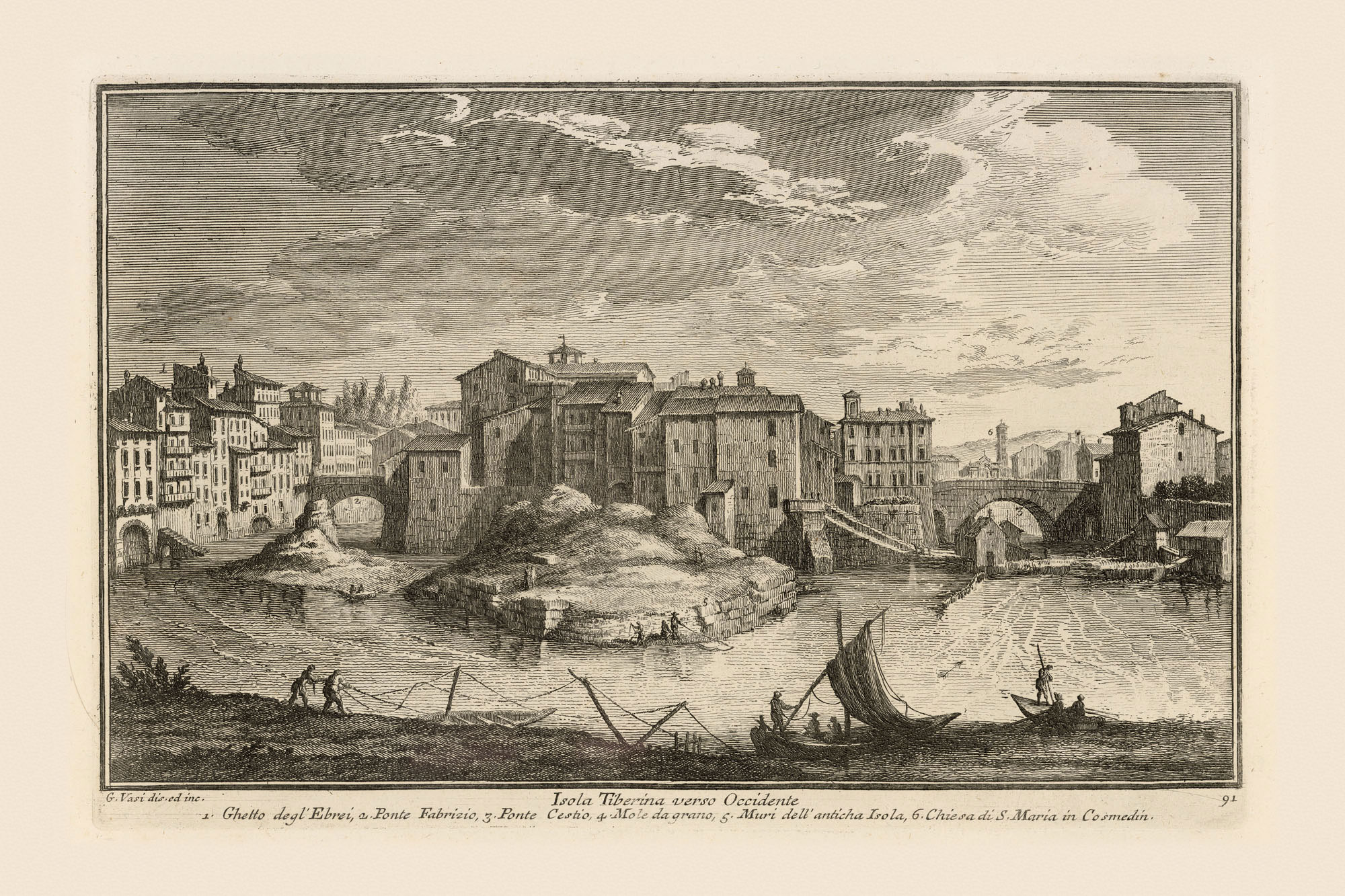
In the forefront men are securing their boats; to the far right is the Jewish Ghetto; there is a landing down to the river; the island is directly ahead with its two bridges; there are four grain mills on the river, Trastevere is to the right; but the small island looks like a pile of sand. In Vasi’s view the river wall of the ghetto looks much the same as the other river walls we’ve seen, but the poverty and overcrowding of the gated and walled ghetto where Jews were forced to live remain hidden. Nolli indicates the Ghetto walls and gates, but he too represents the buildings like the rest of the congested city.
Taking a closer look at the mills, Nolli shows six at or near the Island and two more downstream. Millers relied on a strong current to turn the mill wheels. They knew that Tiber floodwaters could rip the mills from their moorings and send them downriver to crash into the nearest bridge. Rendered in perspective like the ferryboats, we see several mills with a cross affixed to the roof to appeal for divine protection during floods.
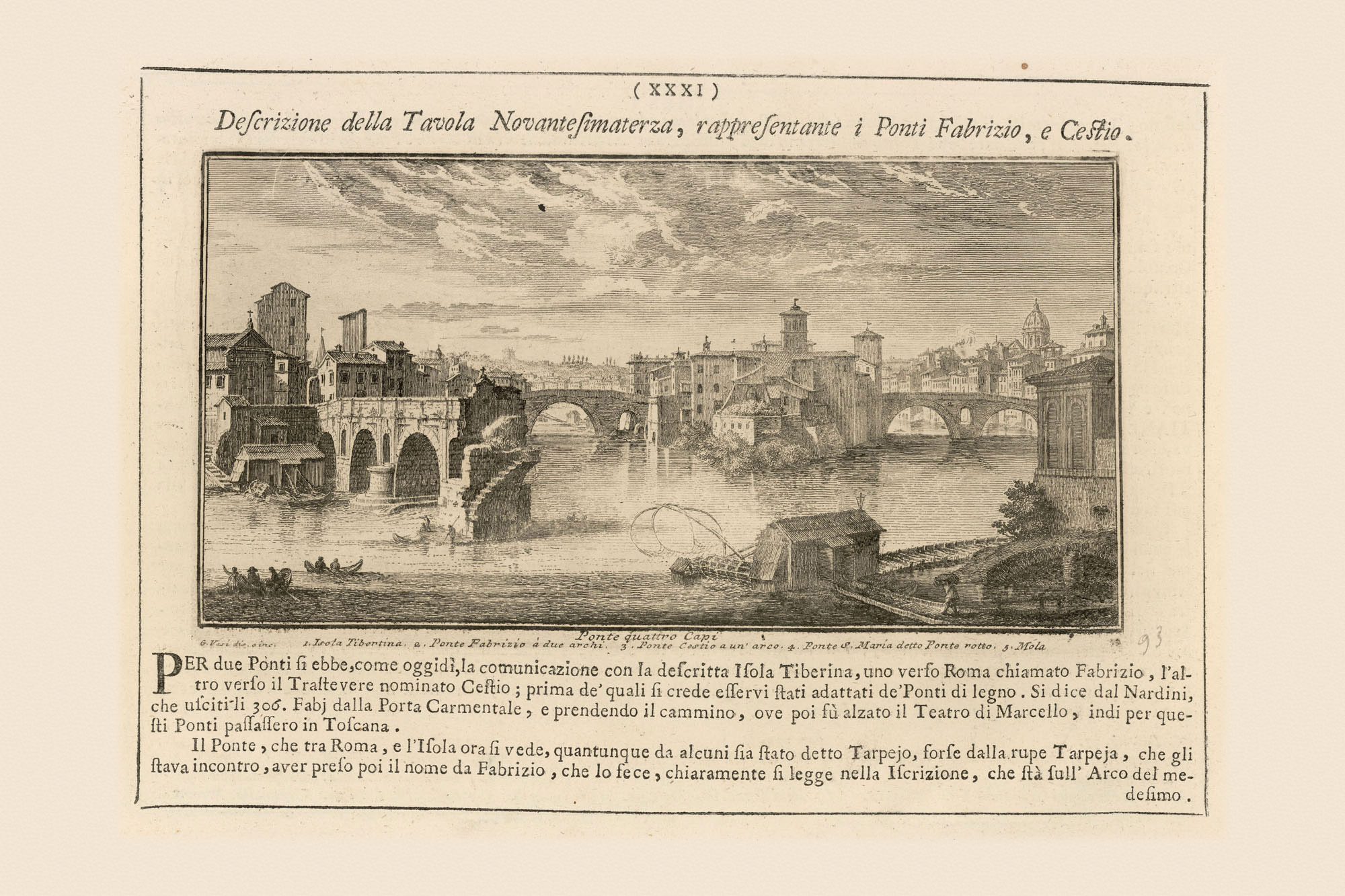
Chiesa and Gambarini have cut a convenient section through the Island. Their depiction includes elevations of Ponte Fabricio (n. 1092), also called Ponte Quattro Capi, and of Ponte Cestio (n. 1099), which Nolli points out was also called Ponte di S. Bartolomeo, though Chiesa and Gambarini call it Ponte Ferrato. The bridges and shore are in a slight perspective view so we can appreciate not only their upstream façades and spans, but also gain some sense of their depths.
I think we should head toward Ponte Fabricio (n. 1092), Rome’s oldest surviving bridge, to see why it has survived. Similar to Ponte Sisto one reason is the opening in the central spandrel that relieves pressure on the entire bridge during floods. Built in 62 BC, the Pons Fabricius was the first bridge to connect Rome’s left bank to the island. Its sponsor—Lucius Fabricius—inscribed his name and date on one downstream arch. The Pons Fabricius gave access to the temple of the healing god, Aesculapius, built there in 292 BC. Before that, ferries transported patients to the island. Today the bridge is sheathed in brick but its core is solid masonry. Pons Cestius spanned to the right bank around 27 BC.

The section elevation also shows the church of S. Bartolomeo all’Isola (n. 1098) and its piazza. The millers had their confraternity chapel there, near to many of their mills. Sailing under the Pons Fabricius, we see the Ghetto walls to our left. Once past the island, Nolli and Vasi, below, show us the ruined Ponte Rotto, the Broken Bridge, with mills beyond.
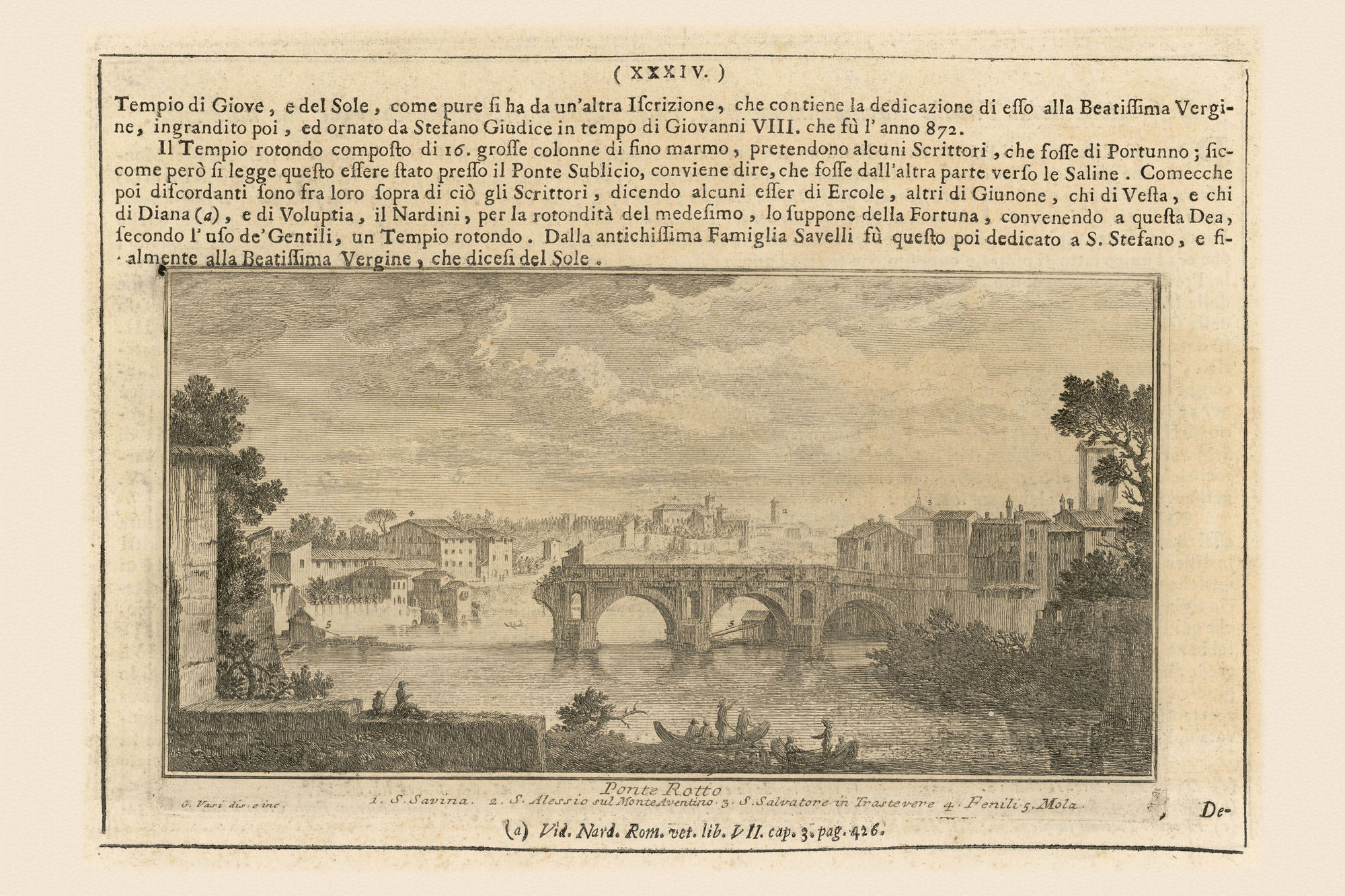
Vasi has us scramble ashore at the downstream tip of the Island to see the bridge, which Nolli also calls Ponte Senatorio (n. 1107). But it was also called Ponte Maggiore, Ponte S. Maria, and, before that, Pons Aemilius—Rome’s first stone bridge, built in 179 BC.
Damaged and rebuilt many times the Pons Aemilius was in the wrong location. Its position below the island, where the two streams reunite to a single channel, preordained its destruction. Water flows faster in narrower streams. There is also more turbulence. As the streams unite, their turbulence and velocity increase for a distance and then the river returns to its usual flow. The bridge’s central pier couldn’t survive the continued pounding of the combined flow: hence Ponte Rotto (broken bridge). The pier to the far right was demolished in the mid-nineteenth century.
Once past the ruins, Vasi turns to look upstream toward Ponte Rotto, Ponte Fabricio, and the island.
But the most interesting aspect is his rendition of the mills that Nolli depicts on the Tiber’s banks. Vasi provides details about its scale and connections to bridges and piers. Vasi also illustrates how other tasks could be performed there: that airy structure suspended by a pole over the Tiber is a fishing net.
From the Tiber’s opposite bank, Vasi provides much greater detail than Nolli could hope to include. In that long garden wall we see two enormous barrel-vaulted stone drain openings: the ancient Cloaca Maxima that drained the area of the Roman Forum to the left, and the Cloaca of the Circus Maximus (n. 1088) that drained the Circus Maximus valley between the Palatine and Aventine Hills to the right. Both drains were built in the sixth century BC.
Vasi illustrates many fishermen along the Tiber but excepting a few men at the ruined piers of Ponte Rotto and a sewer outfall, he never clarifies where they claimed their spots. A license was needed and a fishing platform had to be rented. Nolli fills in this lacuna for the stretch immediately downstream from Ponte Rotto.
Along the right bank there are some small black squares in the water. Those are fishing platforms. Downstream at the “Vestige del Ponte Sublicio” (ruins of Pons Sublicius, ancient Rome’s first bridge, n. 1083). Nolli indicates that walkways connected two piers to the shores. These were coveted fishing sites specifically for catching Luccio and Storione, Northern Pike and Sturgeon respectively.
At the ruined Pons Sublicius we are about to run into trouble, but Nolli gives absolutely no notice. Vasi fortunately helps out.

At the front of his image we see a boat with the ruins not far away. Vasi’s technique renders the water to this side of the ruins as calm and by changing the direction and shortening his ink strokes we learn that the water beyond the ruins is running faster. In fact, the Tiber formed one of its natural weirs in this area; in this case, preventing larger ships from sailing any farther upstream.
Nolli indicates that once we are beyond the piers and the ferry line, we should turn our attention to the right bank and the bustling Ripa Grande. This was Rome’s most important port at the time—about four times larger than the Ripetta at the north—with goods arriving from lands surrounding the Mediterranean Sea and from the Atlantic.
The Aurelian Walls, with the Porta Portese Gate on the right bank define the southern boundary of the port. Behind is the enormous Ospedale Apostolico di S. Michele for delinquent children and orphans.
After negotiating a few more bridge ruins—those of the Pons Probi (n. 1082))—we are free to float along with the current for the next kilometer or so. Although there are still some small buildings, at this point the Aurelian Walls looming on the right bank make clear that we have left the city and entered the Roman Campagna, or countryside.
We pass vineyards all along the left bank while on the right bank a ramp leads to higher ground where one of the city’s granaries and its arsenal are located. Beyond that are more vineyards and the vegetable gardens allotted to the Jewish population.
Soon our view to the left bank is blocked by remnants of the Aurelian Walls , but there are gaps and Vasi, below, helps us see more vineyards and Monte Testaccio beyond.
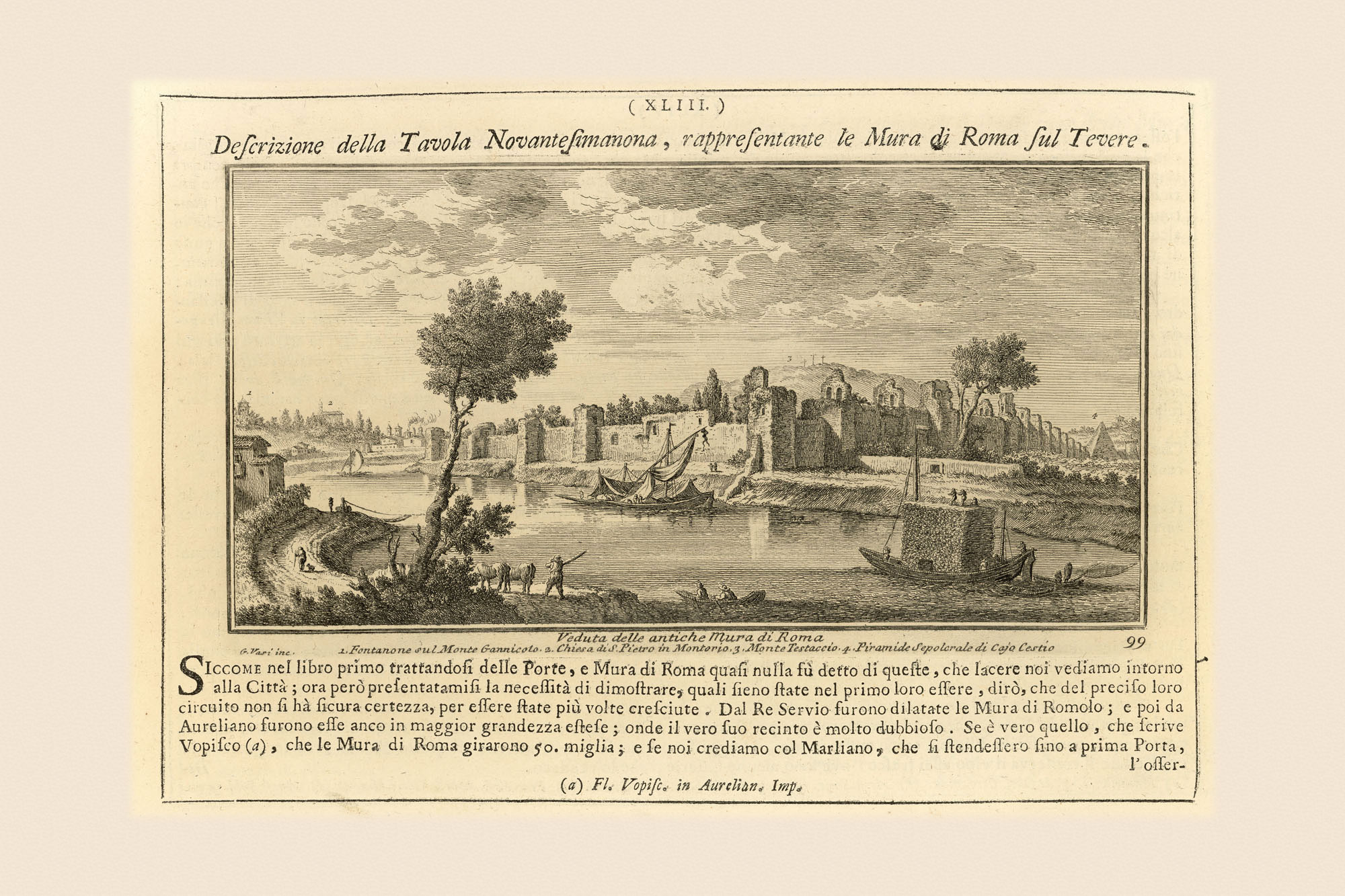
This is the famous hill of potsherds created from discarded oil-filled terracotta amphorae. After decanting the oil into smaller amphorae for distribution, the larger ones, which could only be used once, were tossed into a heap over the course of centuries to create the artificial hill that gives the neighborhood its name. Amphorae and potsherds accumulated from the first century AD until no later than 268 AD, when the port was abandoned. Vasi depicts the Aurelian Walls with the hill beyond, crowned by three crosses. By this time the hill was used for Christian services.
Well, we could keep floating downstream but Father Tiber is impeding our progress on the Nolli Plan. We might as well stop. Someone will have to tow our small skiff back up the river. What a job. It will entail attaching ropes to the prow and then a pair of oxen or a few strong bodies will trudge along the left bank on that little strip of shoreline as far as the ruins of Ponte Sublicio.
At that point everything becomes more difficult and you can understand why boats didn’t travel the entire length of the urban river. Not only did the Ponte Sublicio weir interrupt northward traffic, but the city itself, with garden and building walls at the river’s edge, also blocked movement. It might be wisest to sell our boat and cut our losses.